| |
Presidential
Candidate | Vice Presidential
Candidate | Political
Party | Popular Vote | Electoral Vote |
 | Dwight Eisenhower | Richard Nixon | Republican |
33,937,252 |
55.14% | 33,937,252 |
 | Adlai Stevenson | John Sparkman | Democratic |
27,314,992 |
44.38% | 27,314,992 |
 | Vincent Hallinan | Charlotta Bass | Progressive |
140,160 |
0.23% | 140,160 |
| Stuart Hamblen | Enoch Holtwick | Prohibition |
72,948 |
0.12% | 72,948 |
| Eric Hass | Stephen Emery | Socialist Labor |
30,406 |
0.05% | 30,406 |
| Darlington Hoopes | Samuel Friedman | Socialist |
20,203 |
0.03% | 20,203 |
| Douglas MacArthur | Harry Byrd | Constitution |
17,211 |
0.03% | 17,211 |
| Farrell Dobbs | Myra Tanner Weiss | Socialist Workers |
10,312 |
0.02% | 10,312 |
| Write-ins | - | - |
4,524 |
0.01% | 4,524 |
| Henry Krajewski | Frank Jenkins | Poor Man's Party |
4,203 |
0.01% | 4,203 |
 |
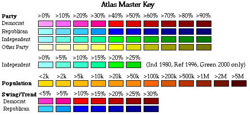
Map Key
| Turnout
 |  |  |
|
| Maps | Map (m) |  | | Rep. (m) | | Dem. (m) | | Swg (m) | | Tnd (m) |
| |
| Demographic Data
| 1960 Population: | 179,323,175 | Enum. | 1960 Population Density: | 19.6 | persons/km2 | | 1950 Population: | 151,325,798 | Enum. | 1950 Population Density: | 16.5 | persons/km2 | | Total Electoral Vote: | 61552211 | | | Land Area (2000): | 9,161,889 | km2 | Annual Pop Growth Rate: | 1.7 | % |
| Election Data and Statistics:
- Data (Table) (m)
- Data (Graphs) (m)
- City and Town Data (m)
|
| | Election Tools
- Atlas Forum Image Code for Maps: County, Town, Tnd, Swg
Data Sources:
- Source for Popular Vote data:
- Source for Population data: U.S. Census Bureau.
| Results for and Individual :
|
|
| |
|


