| |
Presidential
Candidate | Vice Presidential
Candidate | Political
Party | Popular Vote | Electoral Vote |
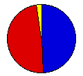
 | William Bryan | John Kern | Democrat |
115,908 |
48.59% | 6 |
 | William Taft | James Sherman | Republican |
116,513 |
48.85% | 2 |
 | Eugene Chafin | Aaron Watkins | Prohibition |
3,302 |
1.38% | 0 |
| Eugene Debs | Benjamin Hanford | Socialist |
2,323 |
0.97% | 0 |
| Thomas Hisgen | John Graves | Independence |
485 |
0.20% | 0 |
 |
Map Key
| Turnout
 |  |  |
|
| Maps | County Map (m) |  |
| |
| Demographic Data
| 1910 Population: | 1,295,346 | Enum. | 1910 Population Density: | 51.2 | persons/km2 | | 1900 Population: | 1,188,044 | Enum. | 1900 Population Density: | 46.9 | persons/km2 | | Total Electoral Vote: | 8 | | | Land Area (2000): | 25,314 | km2 | Annual Pop Growth Rate: | 0.9 | % |
| Presidential Electors:
- Method of Choosing:Popular Vote - Individual Electors
- Table of Presidential Electors for Maryland in 1908 (m)
| Election Data and Statistics:
- County Data (Table) (m)
- County Data (Graphs) (m)
|
| | Election Tools
- Atlas Forum Image Code for Maps: County
Data Sources:
- Source for Popular Vote data: Maryland Secretary of State, comp., "Tabulated Vote for Presidential Electors," Maryland Manual 1908-1909 (Baltimore: John Murphy Co., 1909)
- Source for Population data: U.S. Census Bureau.
| Results for and Individual County:
|
|
| |


