| |
Presidential
Candidate | Vice Presidential
Candidate | Political
Party | Popular Vote | Electoral Vote |
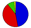
 | William Taft | James Sherman | Republican |
32,333 |
46.98% | 3 |
 | William Bryan | John Kern | Democrat |
29,326 |
42.61% | 0 |
 | Eugene Debs | Benjamin Hanford | Socialist |
5,855 |
8.51% | 0 |
 | Eugene Chafin | Aaron Watkins | Prohibition |
827 |
1.20% | 0 |
| Thomas Hisgen | John Graves | Independence |
481 |
0.70% | 0 |
 |
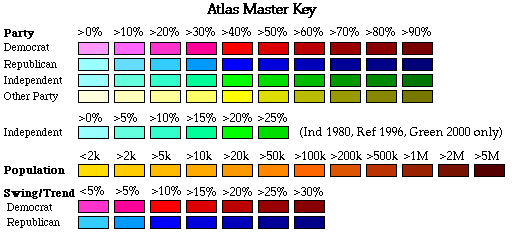
Map Key
| Turnout
 |  |  |
|
| Maps | County Map (m) |  |
| |
| Demographic Data
| 1910 Population: | 376,053 | Enum. | 1910 Population Density: | 1.0 | persons/km2 | | 1900 Population: | 243,329 | Enum. | 1900 Population Density: | 0.6 | persons/km2 | | Total Electoral Vote: | 3 | | | Land Area (2000): | 376,979 | km2 | Annual Pop Growth Rate: | 4.4 | % |
| Election Data and Statistics:
- County Data (Table) (m)
- County Data (Graphs) (m)
|
| | Election Tools
- Atlas Forum Image Code for Maps: County
Data Sources:
- Source for Popular Vote data: Montana Secretary of State, Official Vote of the State of Montana Cast at the Regular Election Held on the 3d Day of November, A.D. 1908 Canvassed by the State Board of Canvassers (Helena: Allied Printing, 0)
- Source for Population data: U.S. Census Bureau.
| Results for and Individual County:
|
|
| |


