| |
Presidential
Candidate | Vice Presidential
Candidate | Political
Party | Popular Vote | Electoral Vote |
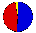
 | Benjamin Harrison | Whitelaw Reid | Republican |
516,011 |
51.45% | 32 |
 | Grover Cleveland | Adlai Stevenson | Democrat |
452,264 |
45.09% | 0 |
 | John Bidwell | James Cranfill | Prohibition |
25,123 |
2.50% | 0 |
| James Weaver | James Field | People's |
8,714 |
0.87% | 0 |
| Simon Wing | Charles Matchett | Socialist Labor |
898 |
0.09% | 0 |
 |
Map Key
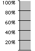
| Turnout
 |  |  |
|
| Maps | County Map (m) |  |
| |
| Demographic Data
| 1900 Population: | 6,302,115 | Enum. | 1900 Population Density: | 54.3 | persons/km2 | | 1890 Population: | 0 | Enum. | 1890 Population Density: | 0.0 | persons/km2 | | Total Electoral Vote: | 32 | | | Land Area (2000): | 116,074 | km2 | Annual Pop Growth Rate: | 0 | % |
| Election Data and Statistics:
- County Data (Table) (m)
- County Data (Graphs) (m)
|
| | Election Tools
- Atlas Forum Image Code for Maps: County
Data Sources:
- Source for Popular Vote data: Pennsylvania Department of General Services, comp., "Official Vote of Pennsylvania for Presidential Electors, 1892," Smull's Legislative Handbook and Manual of the State of Pennsylvania 1893 (Harrisburg: E. K. Meyers, 1893)
- Source for Population data: U.S. Census Bureau.
| Results for and Individual County:
|
|
| |


