| |
Presidential
Candidate | Vice Presidential
Candidate | Political
Party | Popular Vote | Electoral Vote |
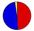
 | James Carter | Walter Mondale | Democrat |
2,011,621 |
48.92% | 25 |
 | Gerald Ford | Robert Dole | Republican |
2,000,505 |
48.65% | 0 |
 | Eugene McCarthy | Dennis Anderson | Not Designated |
58,258 |
1.42% | 0 |
| Lester Maddox | William Dyke | American |
15,529 |
0.38% | 0 |
| Roger MacBride | David Bergland | Not Designated |
8,961 |
0.22% | 0 |
| Gus Hall | Jarvis Tyner | Not Designated |
7,817 |
0.19% | 0 |
| Peter Camejo | Willie Mae Reid | Not Designated |
4,717 |
0.11% | 0 |
| Lyndon LaRouche | R. Wayne Evans | Not Designated |
4,335 |
0.11% | 0 |
| Julius Levin | Constance Blomen | Write-in |
68 |
0.00% | 0 |
| Benjamin Bubar | Earl Dodge | Write-in |
62 |
0.00% | 0 |
 |
Map Key
| Turnout
 |  |  |
|
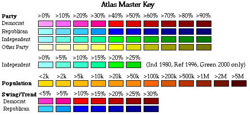
| Maps | 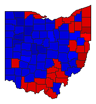 |  | | Pop. (m) | | Dem. (m) | | Rep. (m) | | Swg (m) | | Tnd (m) |
| |
| Demographic Data
| 1980 Population: | 10,797,603 | Enum. | 1980 Population Density: | 101.8 | persons/km2 | | 1976 Population: | 10,752,731 | Est. | 1976 Population Density: | 101.4 | persons/km2 | | 1970 Population: | 10,657,423 | Enum. | 1970 Population Density: | 100.5 | persons/km2 | | Total Electoral Vote: | 25 | | Electoral Vote Density: | 430,109 | persons/EV | | Land Area (2000): | 106,056 | km2 | Annual Pop Growth Rate: | 0.1 | % |
| Election Data and Statistics:
| Election Tools
- Atlas Forum Image Code for Maps: County, Pop, Tnd, Swg
Data Sources:
- Source for Popular Vote data: Ohio Secretary of State, Ohio Election Statistics Election and Registration Statistics General Election, 1976 (Cleveland, 1977)
- Source for Population data: U.S. Census Bureau.
| Results for and Individual County:
|
|
| |


